Colne Valley Walk around Earls Colne - Healthy Life Essex

Explore the delights of the Colne Valley. Enjoy a gentle stroll around Earls Colne, through riverside meadows, ancient woodland and visit the old railway nature reserve.
Follow the Waymarks ............... click here
Wildside 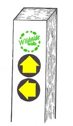 Walks are usually ‘Waymarked’, but be aware that some waymarks are now in dis-repair or even missing. They are found on special posts, stiles, gates and some fingerposts. The posts are usually painted white so that they can be seen from a distance (when needing to cross large fields etc this can be very useful. Tip: Binoculars can be handy to have when looking for the white posts.)
Walks are usually ‘Waymarked’, but be aware that some waymarks are now in dis-repair or even missing. They are found on special posts, stiles, gates and some fingerposts. The posts are usually painted white so that they can be seen from a distance (when needing to cross large fields etc this can be very useful. Tip: Binoculars can be handy to have when looking for the white posts.)
Wildside walk plaques are bright green and unique to Wildside walks in Essex.
Yellow ‘Directional Arrows’ usually on circular disks indicate the direction you should follow. (Path junctions are more complicated! Each arrow indicates an alternative route, so use the map to make your choice.)
Three different types of directional arrow are used:
Plain Yellow: used on ‘official’ public footpaths
Yellow Arrow with Courtesy Footpath: A small number of paths are not ‘official’ public rights of way. Most courtesy paths are in Nature Reserves and are generally provided courtesy of the landowner.
Plain Blue: Used on ‘official’ bridleways. Only found on the Bicknacre walk – look out for horses and cyclists.


| Open a larger scale, printable copy of this map in Adobe pdf format |
|
Mike and Jill of Healthy Life Essex – Walk Review
 Our Colne Valley walk was on 2nd May 2009 and it was a glorious spring day. The ground was fairly dry (apart from Brick Meadows) but, I would imagine, can often be very muddy – so be prepared.
Easy and free car parking was available just off Earls Colne high street. Very convenient as toilets are also available! Within minutes we were out of the village centre, over a stile and heading across the golf course (take care crossing here!) towards the River Colne. A small bridge took us to the other side of the River Colne, which is very narrow at this point, and we followed the White Colne Heritage Trail signs along the Old Railway Nature Reserve, although there are an abundance of other routes that could be taken. Although much of the walk is parallel with the Colne you only actually have fleeting glimpses of the river itself.
The Old Railway Nature Reserve .......................... click here
 The Old Railway Nature Reserve was, until recently, managed by the Essex Wildlife Trust as a nature reserve. The Colne Valley Railway opened in 1860, bringing prosperity to the area. The Hunts built Earls Colne station in 1889 to import raw materials and despatch finished products. (Hunts Atlas Works was one of the most important iron factories in Essex. It specialised in the production of agricultural equipment. It is still the best preserved mid-nineteenth century iron foundry in the county although it is now in a perilous condition.)
The route currently serves as a public footpath joining White Colne, Earls Colne and Colne Engaine and there now plans to improve the route and incorporate it into a long-distance, multi-access path along the Colne Valley.
 The walk along the old railway line itself is delightful: absolutely full of bird song, pretty wild plants and, on the lovely day we took our walk, dappled sunshine glinting through the trees.
Eventually we came to a crossing of paths; and following the White Colne Heritage Trail signs we veered away from the railway line and skirted the sewage works, it became very narrow and uneven and certainly needs a bit of maintenance to ensure its continued accessibility. But it is a beautiful and unspoilt area and we hope future development does not  detract from that.
The footpath crosses Lower Holt Street and continues almost directly opposite via a pathway between two houses, highlighted with a pretty wisteria laden archway. This little route alongside the back garden of  gently rippling river. We walked a while along the riverside, picturesque with grazing sheep and frolicking lambs, past a couple of old gravel pits that are now private fishing lakes, turning right at the end of the track and heading along a short lane towards Chalkney Mill.
Chalkney Mill is an 18th century water mill built initially as a fulling mill, a treatment process for wool, and later for milling corn. Although the water mill is still operational, it last ground corn in the 1930s. The walk takes you back across the Colne, right through the grounds of the mill adjacent to the house and past the kennels. But this is private property and they do ask walkers to respect their privacy!
Immediately adjacent to the mill is Chalkney Wood. Ownership and management of the woods is now split between Essex County Council and the Forestry Commission. The wood is still regularly coppiced, and is accessible to the public at all times.
 One of the most obvious benefits of this management is the wonderful display of bluebells and wood anemones in the spring which we were lucky enough to experience. The coppiced branches seem to mysteriously appear above a delectaible blue haze of flowers. As you enter the wood you can turn almost immediately right at the wood’s edge and follow the path which will take you to a small car park where you turn right and follow the path to the road. We chose to venture further into the woods but there is very little signage and it could be very easy to get lost. As you follow the alternative trail through the first part of this wood, take the first turing to your right which will take you to the car park mentioned previously.
Chalkney Wood ................ click here
Chalkney Wood was owned by the De Vere family until 1605 (they were Earls of Oxford, hence Earls Colne) and they built a prominent bank around the wood to enclose it as a Swine Park. Pigs foraged for acorns amongst the coppice and oaks were left as standards for both timber value and pig fodder. The wood is still coppiced with a plan to coppice the whole wood on a 25 year cycle.
It is thoug ht the wood has been in existence since the last Ice Age and it is rich in natural history. This ancient woodland, which now incorporates different stages of coppice regrowth, provides a rich diversity of wildlife including deer, badgers and over 30 breeding species of birds, together with a number of scarce insect and wildflower species such as the violet helleborine and the unusual herb Paris. The wood is now designated a Site of Special Scientific Interest.
However, this beautiful ancient woodland was under threat during the 1950s and 60s when the national forestry policy was to replant with fast growing conifers for greater profit. Fortunately, this policy has reversed and the conifers have mostly been cleared to once again re-introduce management by coppicing and restore the wonderful wildlife habitat. It consists now mainly of oak, lime, ash, birch, sweet chestnut and a few hornbeam.
There is an interesting path indentation which cuts across the woods. This is believed to be the Wool Track, part of the Roman Road which ran between Colchester and Cambridge, although it is believed the track was in use long before then.
 At the end of the lane, turn left along the road and look at for the footpath sign on the right hand side. The sign is a little bit misleading – you need to stay to the left of the hedgerow on the right-hand side of the field towards a small copse. Stay on this track as it crests a hill with stunning views across the countryside (we had the bonus of bright yellow rape fields when we visited) and the Colne Valley in the distance. Follow the White Heritage Trail waymarks past Tilekiln Farm to the Coggeshall Road. (Local tradition claims that there is a yet undiscovered Roman well at the present-day Tile Kiln Farm)
Turn right along Coggleshall Road. As the road takes a right bend, look out for the waymark on the left hand-side and take the private path between the houses towards the brick meadows.  This is a wild area rich in plants and wildlife for locals to enjoy. Following the waymark signs, turn right without crossing the stile taking you through an area bright with gorse and definite evidence of mole tunnelling! Turn left at the next gate and follow the main part of the path. If you deviate to the left take care – there are some very interesting boggy areas! Follow the footpath around by a large tree secured with metal braces and then straight ahead to a footpath over a brook taking you to Park Lane, turning right and left into Foundry Lane and back to Earls Colne high street.
|
Distance and time taken Going Transport Habitat types |
Ordnance Survey Map Parking Refreshments Dogs |
© Photographs by Mike Wilson 2009
![]() Produced in conjunction with Essex County Council
Produced in conjunction with Essex County Council
Maps reproduced by kind permission of
the Public Rights of Way Dept, Essex County Council
www.essexcc.gov.uk/prow